 |
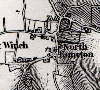 |
This is taken from the David & Charles map "Sheet 45, Downham" (printed by Redwood Books Ltd 1980, ISBN 0715348426). The map is a facsimile copy of the First Edition of the one inch (to the mile) Ordnance Survey. The original was published in 1870, but the mapping was mainly carried out between 1810 and 1820. The map shows a rather exaggerated slope away from North Runcton, and the location of toll points on the King's Lynn to Norwich road. Note that where the road from the village meets the main road, the junction is shown as a crossroads with the road leading north east to what is now Fair Green. This junction is now an offset "dog-leg" junction. |
www.runctonweb.co.uk